A dated Plynth evidence specimen for 41 Donald Street, Hurstville, joining Lot 8 DP8435 to six parcel-linked planning layers and the next questions they create.
At 41 Donald Street in Hurstville, the R2 zone opens the site review. Plynth's parcel join adds a 0.55:1 floor-space ratio, a 9 m height, a 450 m² minimum lot size, an additional-FSR area and a Transport SEPP special-provision layer.
The last two results change the brief. One sends the practitioner to the local environmental plan's additional floor-space-ratio provisions. The other opens a rail-corridor test when a proposal involves excavation at least 2 m below ground. Together they turn a zoning result into a clause and rail-corridor research programme.
Direct answer
Six Plynth planning layers attach to Lot 8 DP8435. Four describe the familiar site controls: R2 Low Density Residential zoning, 0.55:1 floor-space ratio, 9 m maximum building height and 450 m² minimum lot size. Two change the research path: the parcel is in Area 1 on the additional-FSR layer and intersects the Transport SEPP special-provision layer linked to section 2.99.
That evidence changes an early project brief from "What can R2 land accommodate?" to a sharper set of questions: Which clause 4.4A calculation applies to the proposed residential form? Will the work penetrate at least 2 m below ground? How close is that excavation to the rail corridor? Which rail authority notification or concurrence steps belong in the programme?
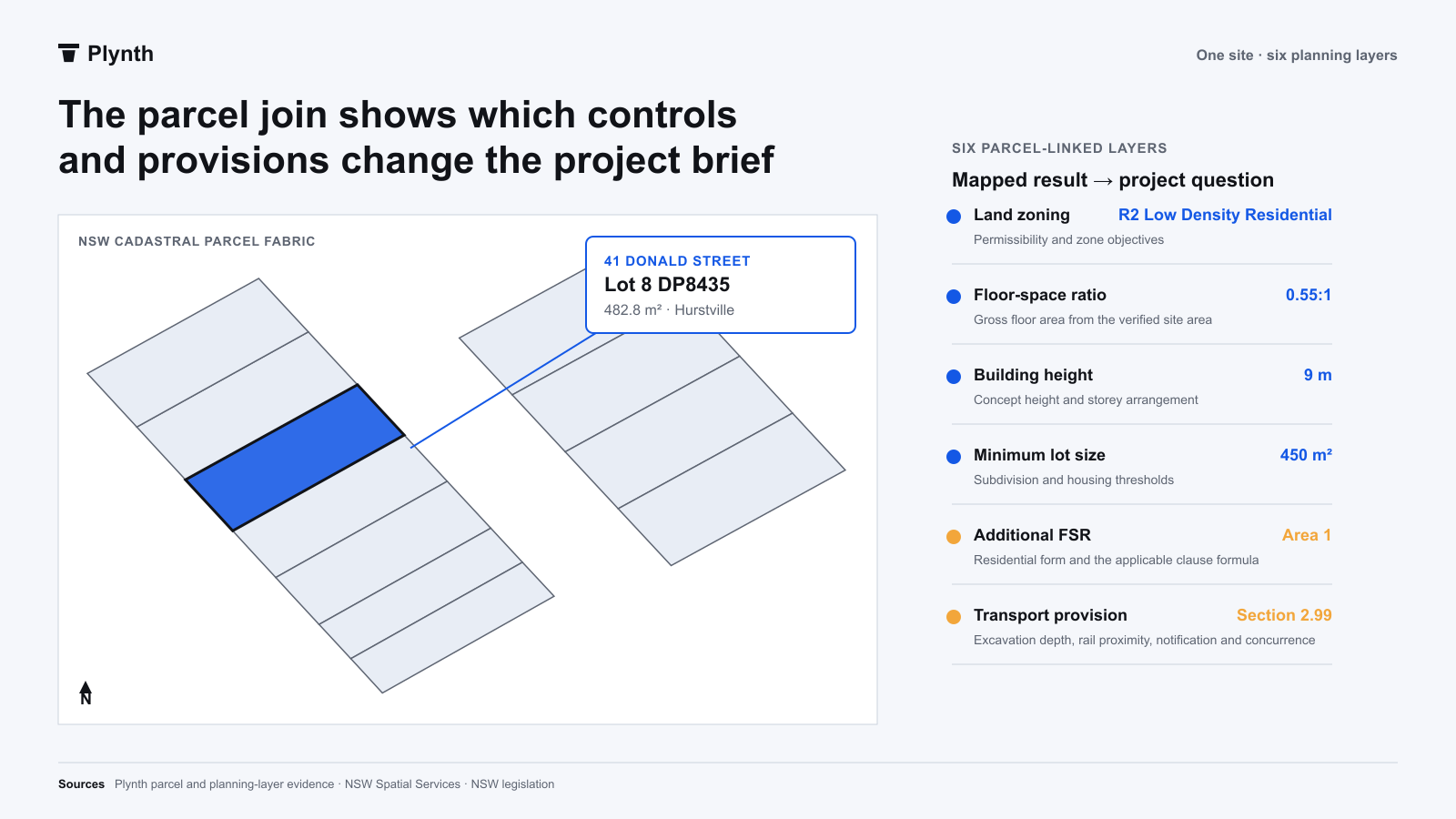
The joined evidence changes the next decision
Six parcel-linked planning layers for 41 Donald Street
The parcel key keeps each mapped value attached to the same site. The final column records the project question created by that evidence.
| Evidence | Plynth result | Source connection | Question added to the brief |
|---|---|---|---|
| Parcel | Lot 8 DP8435; 482.8 m² in the Plynth map | NSW Land Parcel Property Theme | Are every control and proposal assumption attached to the correct land? |
| Land zoning | R2 Low Density Residential | Georges River LEP 2021, Part 2 and Land Zoning Map | Is the proposed use permitted, and which zone objectives shape the assessment? |
| Floor-space ratio | 0.55:1 | Georges River LEP 2021, clause 4.4 and FSR Map | What gross floor area follows from the verified site area and proposal definition? |
| Height of buildings | 9 m | Georges River LEP 2021, clause 4.3 and Height of Buildings Map | How does the concept fit beneath the mapped height control? |
| Minimum lot size | 450 m² | Georges River LEP 2021 and Lot Size Map | Which subdivision or housing provisions use the mapped lot-size threshold? |
| Additional FSR | Area 1 | Georges River LEP 2021, clause 4.4A and Additional FSR Map | Which residential-accommodation formula applies to this parcel and proposal? |
| Transport special provision | Section 2.99 | Transport and Infrastructure SEPP 2021 | Does excavation depth and rail-corridor proximity trigger notification, consultation or concurrence work? |
The two extra overlays carry the strongest insight
The 0.55:1 and 9 m controls help bound a first concept. Area 1 changes how the floor-space-ratio question is framed because clause 4.4A contains additional rules for certain residential accommodation. A practitioner needs the proposed housing type and the clause formula before turning the mapped value into a design assumption.
The transport hit changes a different part of the programme. Section 2.99 of the Transport and Infrastructure SEPP applies to excavation at least 2 m below ground on land in, above, below or within 25 m of a rail corridor. Where those proposal and location tests are met, the consent authority must notify the rail authority and address the section's response and concurrence process. The map hit therefore belongs beside excavation depth and rail proximity in the early brief, where it can shape scope, programme and agency contact.
A source graph keeps the map and clause connected
From address to a source-linked project question
Plynth uses the parcel as the common key, then keeps the mapped result, instrument and practical question together.
- Resolve the land
Match 41 Donald Street to Lot 8 DP8435 and retain the NSW cadastral geometry.
- Read the core controls
Join zoning, floor-space ratio, height and minimum lot size to the same parcel.
- Open the additional provision
Carry the Area 1 hit to clause 4.4A and test the proposed residential form against its calculation.
- Test the transport trigger
Carry the section 2.99 hit into excavation depth, rail proximity, notification and concurrence questions.
- Update the project brief
Record the source, mapped value, date, proposal input and next owner for every material question.
The chain matters because each object does a different job. The cadastral service identifies the land. The LEP maps supply parcel-linked controls. The LEP and SEPP text explain how those mapped results operate. Plynth adds value by keeping the site, values, source identities and next questions in one evidence view that can move into analysis and reporting.
The combined view creates a better research programme
The next round of work is now specific. Define the proposed use and gross floor area, run the clause 4.4A formula for that residential type, establish the excavation depth, measure rail-corridor proximity and identify the responsible rail authority. Then add the relevant DCP controls and nearby development evidence to test how comparable proposals have been designed and assessed.
That final join is a useful product-data opportunity. A reusable link between development applications, the planning provisions they rely on and recorded agency referrals would let Plynth show how often a mapped trigger becomes a material assessment pathway. The candidate dataset has been added to the product-data ledger for backend assessment.
Method and evidence
We resolved 41 Donald Street through Plynth's public mapping surface on 28 August 2026 and confirmed that the map selected Lot 8 DP8435. The NSW Land Parcel Property Theme returned the same lot and deposited-plan identity from its public cadastral service. The subject boundary used in the visual comes from that official geometry.
The six planning-layer values and their vintages come from Plynth's current frontend evidence specimen for the same measured reference parcel. The four core-control layers were recorded with a 17 October 2025 data vintage; the additional-FSR and Transport SEPP layers were recorded with a 25 March 2026 data vintage. We checked the current Georges River LEP and Transport and Infrastructure SEPP on NSW legislation before writing the project questions.